


City offices in Columbus were closed due to flooding Monday morning. (Devan Ridgway/WTIU News)
Track delays, closings submitted to our newsroom and weather alerts here.
Friday, April 11
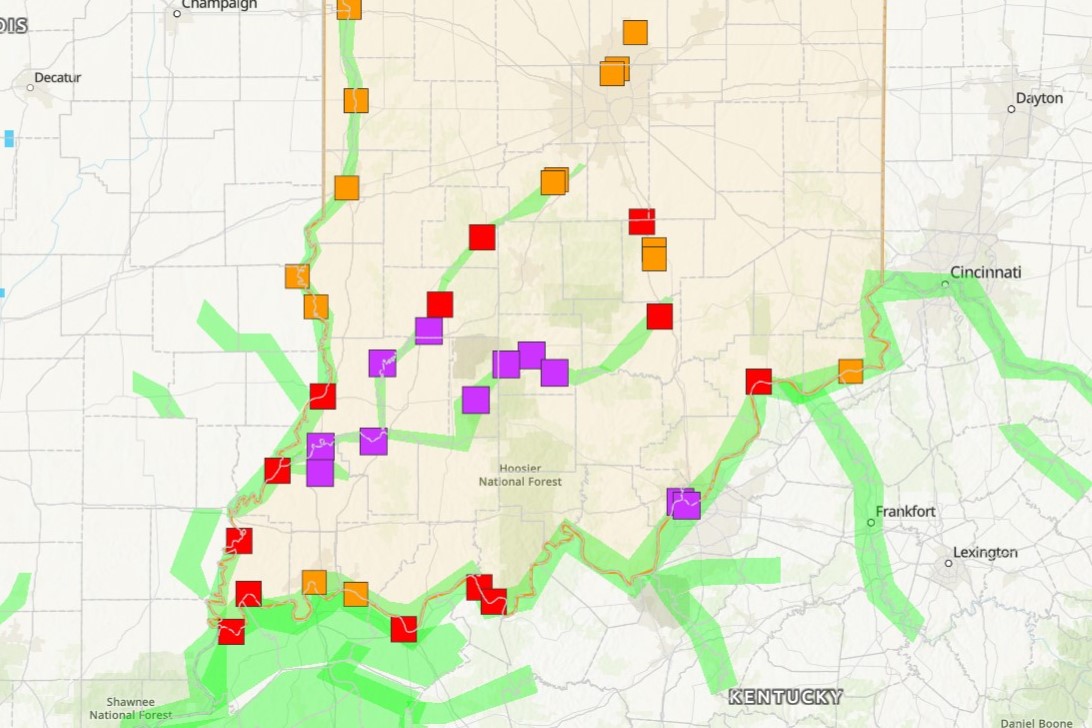
Gov. Mike Braun declared a state of disaster emergency this afternoon for 18 counties affected from tornado, storm and flood damage.
There is a second death from the floods. Bartholomew County Rescue recovered the body of 62-year-old Darrel Voelz from the Driftwood River after he was reported missing Sunday.
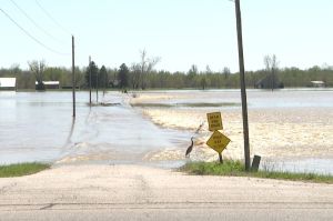
The WFIU/WTIU News team visited the places most affected by the flooding. You can find a recap of all locations here.
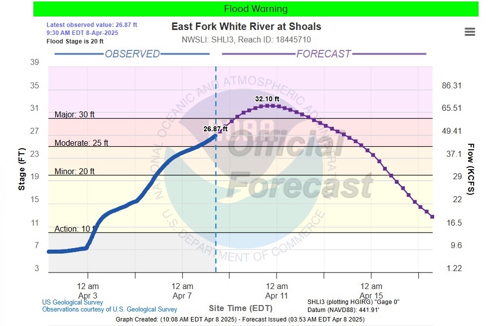
The Martin County Commissioners issued a local disaster emergency declaration on Thursday afternoon. The National Weather Service said the East Fork of the White River at Shoals won’t fall below flood stage levels until around April 17.
The Indiana Dept. of Transportation says it's working to address potholes and other street damage from the severe weather. We have that status update, as well as some Bloomington-specific road conditions.
Wednesday, April 9
AFTERNOON UPDATE:
Flood warnings continue along the White River and its East Fork in south-central Indiana.
Some of the highest river levels are from Seymour to Shoals. The National Weather Service says major flooding should crest in Shoals Thursday night into Friday morning. Levels will be 12 feet above the flood stage as water levels continue to move downstream.
Areas near Bedford are experiencing highest flood levels this afternoon, around 33 feet of flooding.
More rain with the potential for thunderstorms is expected through Thursday night. Rainfall totals are not expected to change river water levels but may delay flood recovery.
Water levels are expected to return to normal near the end of next week.
Read more: Seymour contends with third-highest cresting of flood waters in city history
Tuesday, April 8
9 A.M. UPDATE:
There are eight counties still under a travel watch this morning. The National Weather Service said the East Fork White River in the town of Shoals could see major flooding by Thursday afternoon.
Read more: Town of Shoals braces for seven more feet of flood waters
Vigo County EMS said residents can pick up flood clean-up kits at the Terre Haute Red Cross through Friday during business hours.
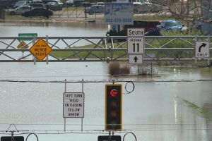
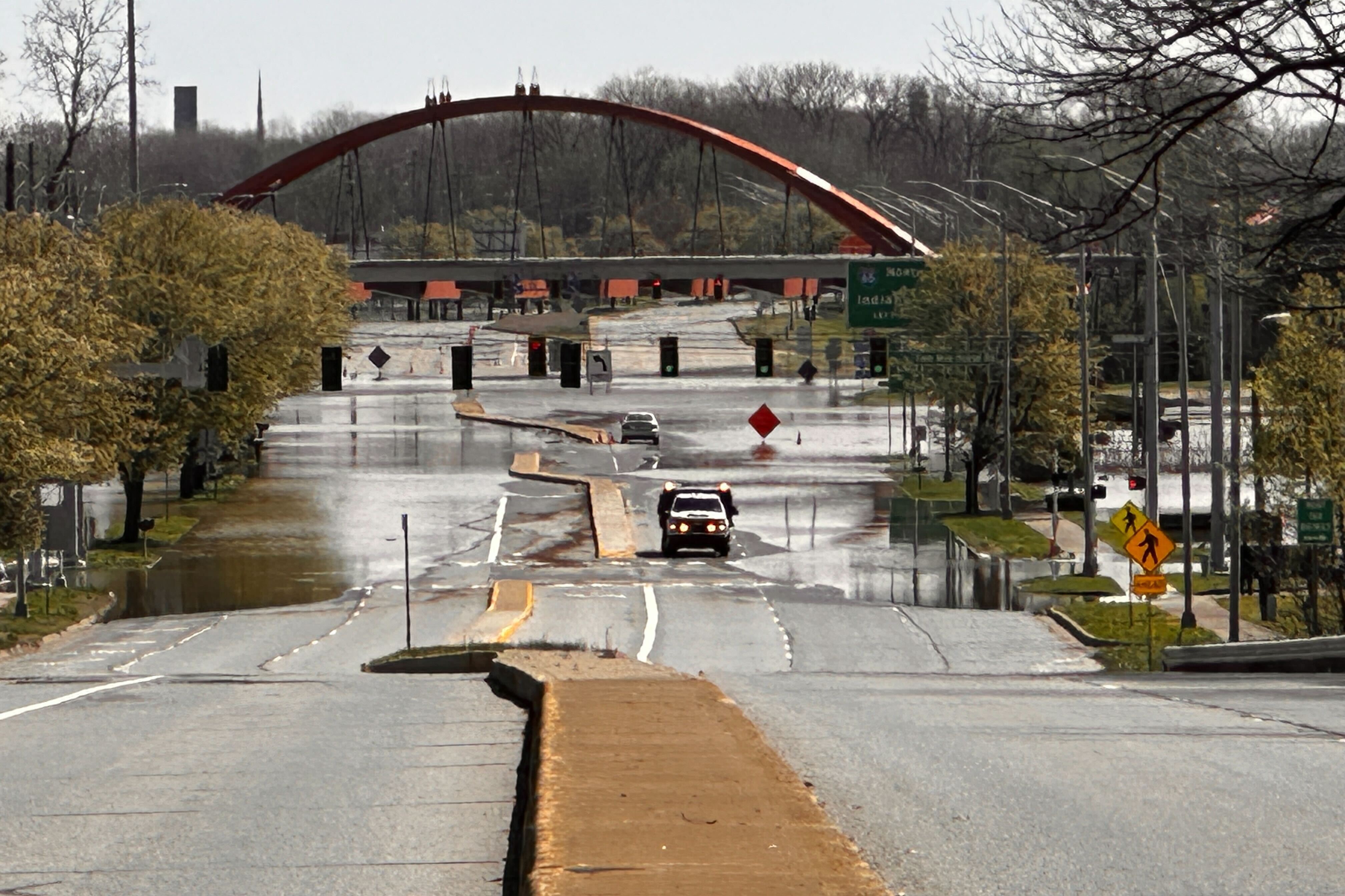
The Bartholomew County EMS said there's still about two dozen roads closed Tuesday morning. SR 46 through Columbus is open, but the traffic lights are still out, according to the Columbus Police Dept.
The Bartholomew County Sheriff's Office and Township Fire and Rescue said they reunited two dogs with their family last night while evacuating the residence.
MONDAY, APRIL 7
11:45 A.M. UPDATE:
NWS Indianapolis issued a flood warning for the following counties: Bartholomew, Brown, Clay, Greene, Jackson, Johnson, Lawrence, Monroe, Morgan, Owen, Putnam, Shelby and Vigo. The warning is effective until 11:30 a.m. Tuesday.
- Roads are blocked by water in Columbus Monday morning. (Devan Ridgway/WTIU News)

7 A.M. UPDATE:
The WFIU/WTIU News team is out reporting on the flooding throughout south-central Indiana. We'll keep you updated through the day.
NWS says there's major flooding along the East Fork White River and the middle to lower White River. There will be moderate flooding on the lower Wabash and upper White Rivers. More flooding is expected to reach downriver Thursday afternoon.
Over two dozen roads are closed in Bartholomew County this morning due to flooding. The county's offices are also closed.
Travel watches or advisories are still in effect for some counties: Morgan, Owen, Clay, Orange, and Washington are some of the Counties under watch.
SUNDAY, APRIL 6
4:00 P.M. UPDATE:
From Bartholomew County Emergency Management:
State Road 46 West, known as Jonathon Moore Pike, between Lindsey St. and Interstate 65 and including entrance and exit ramps to Interstate 65, State Road 11, south of State Road 46 West and Southern Crossing, and Southern Crossing are closed due to ongoing flooding in Bartholomew County. Closures are expected to continue through Monday evening into Tuesday morning. For a full list of closures, visit www.bartholomew.in.gov
1:45 P.M. UPDATE:
The Department of Natural Resources says its officers have recovered the body of a missing man from Mooresville who was sucked into a culvert Saturday morning.
The man was attempting to clear debris from his pond, the DNR said in an emailed statement.
The statement said Bradley Justus, 59, of Mooresville, "was attempting to clear debris near a culvert from a neighborhood pond overflow when he was sucked into the culvert by the force of the flood waters. Rescue efforts were hindered by the hazardous water levels."
Authorities recovered Justus's body just before noon, and the incident is under investigation, according to the DNR.
12:15 P.M. UPDATE:
Indiana State Police say that the northbound and southbound lanes of I-69 south of Bloomington have reopened from the US231 exit to the US50 exit.
11:15 A.M. UPDATE:
The Brown County emergency management agency released a list of roads that are not passable as of 11 a.m. Sunday morning.
JACKSON CREEK OFF 46W - NOT PASSABLE
TC STEELE OFF 46W - NOT PASSABLE
YELLOWWOOD OFF 46W - NOT PASSABLE
GREEN VALLEY RD/MARLETTE RD - NOT PASSABLE
GREEN VALLEY - WEST OF 2326 (THE BRIDGE) - NOT PASSABLE
SR 135 SOUTH OF STORY - CLOSED
SR 135S BETWEEN MT. NEBO AND ELKINSVILLE RD - CLOSED
"The culverts are gone at Hoover, Grandma and Salmeron," the agency said.
9:00 A.M UPDATE:
The Brown County sheriff and commissioners reduced the travel status Yellow/Advisory, the lowest designation. County officials say travel or activities may be restricted in areas because of a hazardous situation, and individuals should use caution or avoid those areas.
SATURDAY, APRIL 5
10:15 P.M. UPDATE:
Indiana Department of Transportation and Indiana State Police are reporting that northbound and southbound lanes of I-69 south of Bloomington are closed due to high water. The closures are between SR58 E to US231 S to US50 W I69 and US50 E to US231 N to SR58 W.
9:00 P.M. UPDATE:
The Indiana Department of Natural Resources reports that conservation officers have responded to more than 40 water-related calls since Friday afternoon. In an emailed statement, the DNR reports that many of the calls involved motorists who attempted to drive through flood waters.
The DNR reminded Hoosiers that it's never safe to drive into floodwaters. More flood safety tips are available on the Indiana Department of Homeland Security's website.
5:45 P.M. UPDATE:
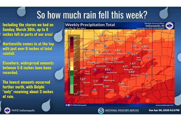
Parts of central and southern Indiana could see up to 7 inches of rain by Sunday causing major river flooding through mid-April.
A flood warning is in effect for most of central and southern Indiana until 11 p.m. Saturday. Numerous river warnings are in effect.
Owen and Morgan counties are under travel warnings — restricting travel to emergency workers only. Brown county has issued a disaster emergency declaration.
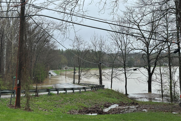
National Weather Service officials said rivers, creeks, streams, and low-lying areas are flooding. Numerous roads are closed due to flooding.
Monroe county officials are listing road closures due to high water here. Columbus and Bartholomew county here — note the looming closure of SR 46 west as flood waters rise. Vigo county is updating their Facebook page.
Around 4.5 inches of rain has fallen over the past 24 hours with additional rainfall of 1.5 inches expected.
With most of Central Indiana expecting an additional 1 to 2 inches of precipitation today we will see a continued threat of both Flash Flooding and River Flooding. #INWX #TurnAroundDontDrown pic.twitter.com/UfTZPEXGth
— NWS Indianapolis (@NWSIndianapolis) April 5, 2025
Turn around, don't drown when encountering flooded roads. Most flood deaths occur in vehicles.
River banks and culverts can become unstable and unsafe. Flooding is occurring or is imminent. Campers and hikers should avoid streams or creeks.
Officials are asking the public to report observed flooding to local emergency services or law enforcement and request they pass this information to the National Weather Service when you can do so safely.